")
Introduction
Arbitrators who handle real estate disputes regularly encounter one category of technical evidence that stands apart from almost everything else they will evaluate: land surveying evidence. Unlike financial records, medical reports, or engineering assessments, surveying evidence is rooted in a discipline that is simultaneously highly technical and deeply historical. It involves the interpretation of documents that may be decades or centuries old, field measurements taken under imperfect conditions, and professional standards that have evolved significantly over time.
For an arbitrator — even one with strong real estate law experience — understanding how to evaluate surveying evidence requires some foundational knowledge that legal training alone does not provide. This article addresses the most important concepts an arbitrator needs to understand when surveying evidence is at the center of a boundary, easement, title, or riparian rights dispute.
The goal is not to turn arbitrators into surveyors. It is to help arbitrators ask better questions, identify stronger evidence, and understand why one surveyor’s opinion may be more credible than another’s even when both are licensed professionals.
The Nature of Surveying Evidence
Surveying is not simply measurement. A land surveyor does not go to a parcel and measure where the boundary ‘is’ the way a technician reads a thermometer. The surveyor’s job is to interpret a body of evidence — legal descriptions in deeds, recorded plats, historical monuments, record of occupation, and physical field evidence — and make a professional determination of where the boundary was originally established and how it should be located today.
This distinction matters enormously in any dispute. Two licensed surveyors can examine the same parcel and reach different conclusions without either one being negligent, because the interpretive process requires professional judgment about which evidence to prioritize when sources conflict. Understanding this does not mean all surveying opinions are equally valid — far from it. But it does mean that evaluating surveying evidence is not simply a matter of counting which expert has more credentials or which report is longer.
Primary Types of Surveying Evidence in Dispute Cases
- Original deeds and legal descriptions: The written instruments that established the boundary. These must be read in light of the time they were drafted and the surveying conventions of the period.
- Historical plats and maps: Recorded survey plats, subdivision maps, and government survey records that show how the land was originally divided and monumented.
- Physical monuments: Stakes, pins, pipes, stones, or natural features called for in the deed or plat. Found monuments are typically given priority over calculated positions.
- Record of occupation: Fences, walls, driveways, and other improvements that reflect how the parties have used the land, which may give rise to legal doctrines like adverse possession or acquiescence.
- Historical records: Historical deeds, tax records, aerial photographs, and other documentary evidence that can help establish the chain of boundary location over time.
- Field measurements: The surveyor’s own measurements taken in the field, used to locate monuments and calculate boundary positions from the deed description.
How to Evaluate Competing Expert Opinions
In a disputed boundary or easement matter, both parties typically retain their own surveying experts who reach different conclusions. Arbitrators frequently struggle with how to evaluate these competing opinions when both experts are licensed professionals with plausible-sounding reasoning.
The key is not to pick a winner based on credentials alone, but to evaluate the methodology each expert employed. The following questions cut to the heart of the analysis:
Questions Every Arbitrator Should Ask About Surveying Expert Testimony
- What evidence did the expert start from? A proper boundary survey begins with the original deed calls and works outward from there. An expert who started from a neighboring survey and worked backward may have introduced error at the outset.
- Did the expert find and consider all available monuments? Found monuments — physical markers from the original survey that can be located on the ground — are typically given the highest evidentiary weight in boundary disputes. An expert who ignored found monuments in favor of a mathematically calculated position has likely applied the wrong methodology.
- Did the expert research the chain of title? Boundary opinions that do not account for the full history of how land was conveyed are incomplete. Title research is part of proper boundary surveying.
- Is the expert’s methodology consistent with published standards? The Minimum Standard Detail Requirements for ALTA/NSPS Land Title Surveys and state surveying standards provide a framework for what constitutes proper practice. An expert opinion that departs from those standards needs to explain why.
- Can the expert explain the basis for every significant decision? A credible expert can walk through their reasoning step by step. An expert who relies heavily on ‘professional judgment’ without specific reference to evidence or standards deserves more scrutiny.
- Is the expert objective? The most dangerous testimony in a land dispute comes from an expert who is transparently advocating rather than analyzing. An expert who was retained by plaintiff and reached the exact conclusion plaintiff needed deserves more rigorous cross-examination than one whose opinion cost their client something.
Common Mistakes in How Surveying Evidence Is Presented
Many attorneys who litigate property disputes infrequently make the same mistakes when presenting or examining surveying evidence. Arbitrators who understand these mistakes are better equipped to draw out the most reliable analysis.
Mistake 1: Letting the Expert Use Jargon Without Translation
Surveying has its own vocabulary — bearings, azimuths, deed calls, meander lines, monuments, PLSS, section corners, quarter corners, riparian boundaries, ordinary high water mark — and expert witnesses who are not accustomed to working with non-surveyor decision-makers often use this language without adequate translation. Push for plain-language explanation. If an expert cannot explain their conclusion in ordinary language, that is an analytical problem, not just a communication problem.
Mistake 2: Focusing on the Result Rather Than the Method
Attorneys often try to win surveying disputes by attacking the other expert’s conclusion rather than their methodology. The better approach — for both presenting counsel and for the arbitrator evaluating the evidence — is to focus on method. How did each expert reach their conclusion? Which expert’s methodology is better supported by the documentary evidence and by professional standards? The conclusion that flows from the better method is almost always the more reliable answer.
Mistake 3: Treating All Surveys as Equal
Not all surveys are created for the same purpose, and not all surveys establish the same legal conclusions. A mortgage survey, an as-built survey, a topographic survey, and a boundary survey are different products. An arbitrator who does not understand this distinction may give inappropriate weight to a survey that was never intended to establish a legal boundary position.
Presenting Surveying Evidence Effectively: A Guide for Counsel
For attorneys presenting surveying evidence in arbitration, the following principles will help ensure the evidence lands effectively with an arbitrator:
- Visual exhibits are essential: Surveying is a spatial discipline. A well-prepared survey exhibit — a scaled plat showing the disputed area, the monuments, the deed lines, and each party’s claimed boundary — is worth more than any amount of verbal testimony. Invest in clear, professionally drafted exhibits.
- Chronological narrative helps: Boundary disputes often turn on historical evidence. A chronological narrative of how the land was originally divided, how ownership transferred, and where the dispute arose helps an arbitrator follow the analysis.
- Establish the standard of care early: In surveyor negligence cases, establish what a reasonable professional land surveyor was required to do before presenting your expert’s opinion on whether those standards were met.
- Let the expert teach: The best surveying expert witnesses are educators, not advocates. A witness who helps the arbitrator understand the discipline and then applies that understanding to the facts at hand is more persuasive than one who simply asserts a conclusion.
About Dr. Tony Nettleman
Dr. Tony Nettleman holds a law degree, a PhD, and three degrees in surveying. He has served as an expert witness in boundary, easement, title, riparian, and surveyor negligence cases in both litigation and arbitration across the United States. His testimony has never been successfully challenged on Daubert grounds. He is a co-author of two leading legal aspects textbooks used in surveying education and has published extensively in academic and trade journals. Dr. Nettleman is available to serve as an expert witness for plaintiff or defense counsel and provides objective, evidence-based analysis regardless of which side retains him.
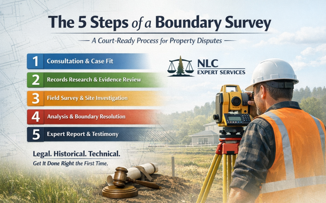
Need a Court-Ready Boundary Survey Process?
If you are already involved in a property dispute or litigation is likely, starting with a structured, expert-led process matters.
NLC Expert Services begins with a free consultation to determine fit and recommend the correct next step.
✅ Take the Quiz to see if you need an Expert Surveyor


0 Comments