
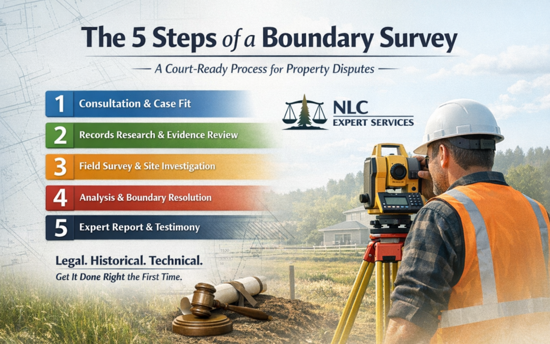
The process of conducting a field survey is a crucial step in various domains, including environmental science, archaeology, urban planning, and civil engineering. However, before embarking on a field survey, it is imperative to undertake a comprehensive records search. This preliminary step involves gathering and analyzing existing documentation, data, and historical records relevant to the survey area. A thorough records search serves as the foundation upon which a successful field survey is built, providing critical insights that can significantly impact the survey’s accuracy, efficiency, and overall success.
Understanding Land Records
A records search helps surveyors gain a comprehensive understanding of the survey area’s historical, social, and environmental context. By delving into historical documents, land use records, and maps, surveyors can trace the area’s evolution over time, identifying past land management patterns, property boundaries, and any significant changes that may have occurred. This historical context can shed light on potential sources of contamination, archaeological significance, or legal issues that might affect the survey. Without a thorough understanding of the context, surveyors might overlook crucial details that could affect the survey’s accuracy and interpretation.
There are a myriad of different types of land document records you may encounter when you search official records . These include:
- Deeds and Title Records
Deeds and title records are foundational legal documents in land ownership and transfer. These records outline the legal history of ownership and transactions related to a specific property. Deeds typically include legal description about the property’s boundaries, dimensions, and any encumbrances or easements affecting the land. Title records, on the other hand, provide a chain of ownership, indicating who has owned the property over time. These records are essential for understanding property boundaries and potential legal issues that might impact the field survey.
- Plat Maps and Surveys
Plat maps, also known as cadastral maps, are detailed drawings that depict property boundaries, dimensions, and geographic features. These maps often accompany deeds and provide a visual representation of the land’s layout. Similarly, surveys conducted by licensed surveyors offer accurate measurements of property boundaries and other relevant features. Reviewing plat maps and surveys from various periods can help researchers identify changes in land use, property divisions, and potential discrepancies over time.
- Zoning and Land Use Records
Zoning and land use records are crucial for understanding how a specific area is regulated and designated for various purposes. Municipalities establish zoning codes that determine allowable land uses, building setbacks, height restrictions, and other development regulations. These records inform surveyors about the legal constraints and potential uses of the land, guiding the survey’s focus and design. Identifying zoning changes over time can reveal shifts in urban development and help assess potential impacts on the survey area.
- Tax Assessment Records
Tax assessment records provide information about real property values, ownership, and tax payments. These records are maintained by local government agencies and can offer insights into changes in property owner information and land use over time. Property tax assessment records may also include tax maps that can provide details about property improvements, such as buildings, fences, or other structures. Surveyors can use this property information to assess the impact of such improvements on the survey area and understand the context in which they were constructed.
- Historic Land Use Documents
Historic land use documents, such as land grants, land patents, and homestead records, offer glimpses into the early history of the survey area. These public records often reveal the original purpose for which the land was granted or settled. Researchers can uncover information about the area’s initial use, such as agricultural activities or mining operations, which can provide insights into potential soil contamination or artifacts of historical significance.
Pre-Survey Checklist
A pre-survey checklist is a crucial tool for ensuring the success and efficiency of a field survey. It helps researchers and surveyors prepare adequately for data collection, reducing the likelihood of errors and setbacks.
- Define Survey Objectives: Begin by clearly defining the goals and objectives of your field survey. Understanding the purpose of the survey will guide your preparations and data collection efforts.
- Review Research Questions: Ensure that the survey questions align with your research objectives and hypothesis. Review and refine the questions to collect the most relevant data.
- Select Survey Methodology: Determine the most appropriate survey methodology, whether it’s interviews, questionnaires, observations, or a combination of these. Ensure that your chosen method aligns with your research goals.
- Secure Necessary Permissions: Obtain any required permits or permissions to access survey locations, especially if they are private properties or restricted areas.
- Assemble Survey Tools: Gather all the necessary equipment, such as survey forms, pens, tablets, cameras, GPS devices, and any specialized tools required for data collection.
- Recruit and Train Survey Team: If you have a survey team, ensure that they are well-trained in survey techniques, ethics, and safety protocols. Assign specific roles and responsibilities to team members.
- Prepare a Schedule: Create a detailed survey schedule, including dates, times, and locations for data collection. Allocate sufficient time for each survey session.
- Test Survey Instruments: Conduct a pilot test of your survey instruments to identify and rectify any issues with questions, instructions, or equipment.
- Consider Safety Measures: Evaluate potential safety risks associated with the survey locations. Implement safety protocols, provide necessary protective gear, and have a first-aid kit on hand.
- Data Management Plan: Develop a plan for data management, including how data will be recorded, stored, and secured during and after the survey.
- Logistical Arrangements: Arrange transportation, accommodations, and meals for the survey team if the survey will take place over an extended period or in remote areas.
- Contact Local Authorities: Inform local authorities, emergency services, or relevant stakeholders about your survey activities to avoid any misunderstandings or conflicts.
- Communication Plan: Establish a communication plan for the survey team, ensuring everyone has access to phones or radios and knows how to contact each other in case of emergencies.
- Weather Considerations: Monitor weather forecasts and have contingency plans in case of adverse weather conditions that could impact the survey.
- Ethical Considerations: Review ethical guidelines and ensure that the survey complies with ethical standards, including obtaining informed consent from participants.
By meticulously following this pre-survey checklist, you can enhance the quality, efficiency, and safety of your field survey, increasing the likelihood of achieving your research goals effectively.
Benefits of Conducting a Land Records Search
Land surveyor expert witnesses will reap great benefits from performing a thorough records research process prior to conducting a field survey. Among these benefits include:
Identifying Potential Hazards and Constraints
One of the primary benefits of conducting a records search is the identification of potential hazards and constraints in the survey area. This information is critical for ensuring the safety of surveyors and preventing any adverse impacts on the environment or surrounding communities. Records may reveal the presence of underground utilities, contaminated sites, or unstable geological conditions. By uncovering these potential challenges beforehand, surveyors can take appropriate precautions and develop effective strategies to mitigate risks during the field survey.
Legal and Regulatory Considerations
A thorough records search helps surveyors navigate the complex legal and regulatory landscape that governs land use and development. By reviewing property deeds, land ownership records, and zoning regulations, surveyors can ensure that their survey activities comply with relevant laws and regulations. Failure to address these considerations could lead to legal disputes, delays, or even project cancellations. By identifying any encumbrances, easements, lien or property disputes, surveyors can proactively address these issues and avoid costly legal complications down the road.
Optimizing Survey Design and Methodology
The information gathered during a records search provides essential insights for designing an effective survey methodology. For example, historical aerial imagery can help surveyors identify areas that have undergone significant changes over time, enabling them to focus their efforts on regions with higher potential for finding relevant data or artifacts. Similarly, property records can assist in determining access points and identifying key locations for survey activities. By tailoring the survey design to the historical and contextual information gathered, surveyors can optimize their efforts and improve the chances of achieving meaningful results.
Preserving Cultural and Historical Significance
In fields such as archaeology and cultural heritage preservation, a thorough records search is crucial for identifying and preserving valuable historical and cultural resources. Historical records, maps, and original documents can provide insights into the presence of archaeological sites, historic buildings, or other culturally significant features. By pinpointing these resources before conducting a field survey, researchers can develop strategies to avoid disturbing or damaging them during their work. This approach ensures that valuable historical and cultural information is preserved for future generations.
Enhancing Survey Accuracy and Interpretation
The accuracy and reliability of a field survey’s findings heavily depend on the quality of the data collected. By conducting a records search, surveyors can identify potential sources of bias or inaccuracies in their survey results. For example, if historical records indicate that an area has been prone to flooding or erosion, surveyors can adjust their data collection methods to account for these factors. Additionally, by comparing historical maps with current conditions, surveyors can identify changes in topography, vegetation, and land use that might affect their interpretations. This attention to detail enhances the accuracy and credibility of the survey’s conclusions.
Cost and Time Efficiency
While it might seem counterintuitive, investing time and resources in a thorough records search before a field survey can actually lead to significant cost and time savings in the long run. By identifying potential challenges, hazards, and constraints early on, surveyors can allocate resources more efficiently and avoid unexpected setbacks. Moreover, a well-informed survey design based on historical information can lead to more focused and targeted data collection efforts, reducing the need for extensive rework or follow-up surveys.
In sum, a thorough records search is an indispensable step before conducting a field survey. The insights gained from historical documents, land record, and other relevant sources provide surveyors with valuable context, help identify potential hazards, ensure legal compliance, optimize survey methodologies, preserve cultural significance, enhance accuracy, and lead to cost and time efficiency. Neglecting this crucial step can result in inaccuracies, legal issues, safety hazards, and missed opportunities to uncover valuable information. By prioritizing a comprehensive records search, surveyors lay the foundation for a successful and impactful field survey that contributes meaningfully to the advancement of knowledge and the betterment of society.
How to Perform a Land Records Search
Future Trends
Understanding future trends in the domain of land records research is essential for staying ahead in data collection and analysis. Some of the anticipated developments in field survey records research are highlighted below:
- Advanced Data Collection Technologies: The future of field survey records research will see a significant shift towards advanced data collection technologies. Drones, LiDAR (Light Detection and Ranging), and remote sensing will become more prevalent. These technologies will enable researchers to gather data more efficiently, accurately, and on a larger scale.
- Integration of AI and Machine Learning: Artificial intelligence (AI) and machine learning (ML) will play a pivotal role in field survey records research. These technologies will automate data processing, analysis, and pattern recognition, allowing researchers to extract valuable insights from large datasets quickly.
- Blockchain for Data Security: As the importance of data security grows, blockchain technology will find applications in field survey records research. Blockchain will ensure the integrity and immutability of collected data, reducing the risk of tampering and unauthorized access.
- Real-time Data Streaming: With the advancement of IoT (Internet of Things) devices, field survey data will be streamed in real-time. This will enable researchers to make immediate decisions, monitor changes as they happen, and respond to emerging trends promptly.
- Collaborative Research Platforms: Field survey records research will benefit from collaborative online platforms. These platforms will facilitate data sharing, collaboration among researchers, and the creation of comprehensive datasets with contributions from multiple sources.
- Open Access Databases: There will be a push for open access to field survey data, promoting transparency and fostering interdisciplinary research. Open databases will encourage data reuse and stimulate innovation in various domains.
- Ethical Data Collection and Privacy: As data collection becomes more invasive with advanced technologies, ethics and privacy concerns will become paramount. Researchers will need to adhere to strict ethical guidelines and prioritize data privacy to maintain public trust.
- Citizen Science Engagement: Engaging citizens in data collection efforts through mobile apps and crowd-sourced initiatives will become more prevalent. This will expand the reach of field survey records research and empower communities to contribute to scientific endeavors.
- Customized Data Visualization: Researchers will increasingly use advanced data visualization tools to convey their findings effectively. Customized and interactive visualizations will make complex field survey data more accessible to a broader audience.
The future of field survey records research promises to be technologically driven, collaborative, and ethically mindful. Researchers and practitioners in this field must adapt to these trends to maximize the impact of their work and address pressing societal and environmental challenges
For more information, please contact the NLC team today!


0 Comments