Boundary retracement is more than just re-measuring a property line — it’s a legal, historical, and technical investigation into where boundaries were originally placed and how they can be correctly re-established today. In this first video of the Boundary Surveying Series, Dr. Tony Nettleman introduces one of the most important (and misunderstood) tasks in land surveying: the boundary retracement survey.
Whether you’re a student preparing for the FS exam, a licensed surveyor looking to sharpen your retracement logic, or simply curious about how surveyors “solve” boundary puzzles — this series is built for you.
What is a Boundary Retracement?
A boundary retracement survey is performed when a landowner, attorney, or agency wants to know:
“Where is my property line, based on original legal intent?”
Unlike original surveys that establish property lines for the first time, retracements attempt to follow in the footsteps of the original surveyor, using a combination of:
- Historical deed records
- Monuments in the field (old fences, rebar, stakes, etc.)
- Legal descriptions
- Case law and professional judgment
This process requires both science and art — the measurements matter, but so does the surveyor’s interpretation of legal hierarchy, conflicting records, and real-world evidence.
What Happens During a Retracement Survey?
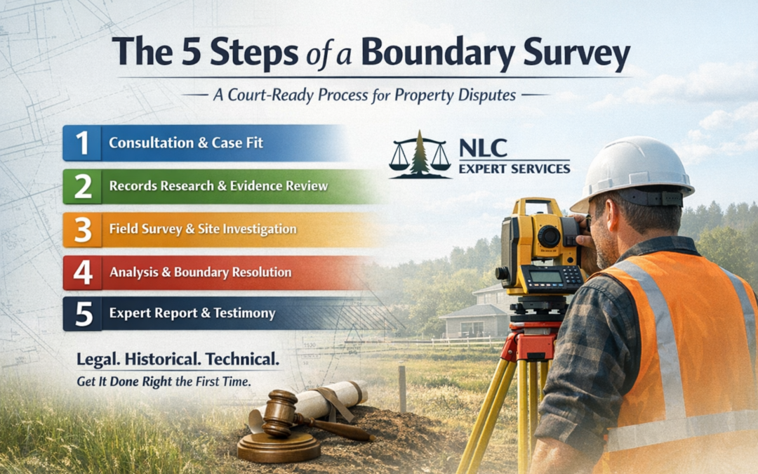
Tony previews that in upcoming videos, he’ll walk through how a retracement survey is actually performed, but here’s a quick look at the core phases every surveyor should master:
1. Record Research
- Gathering deeds, subdivision plats, prior surveys, and public records
- Identifying the chain of title and legal history of the parcel
- Looking for ambiguities or gaps that might affect boundary location
2. Field Investigation
- Locating existing monuments and comparing to record descriptions
- Using total stations, GNSS, and other tools to verify geometry
- Searching for evidence of original survey intent (even if undocumented)
3. Boundary Analysis
- Applying legal principles like “senior rights,” “call for monuments,” etc.
- Resolving conflicts between measured lines and recorded deeds
- Re-establishing boundaries based on original intent — not just math
4. Reporting & Mapping
- Creating a new boundary plat, signed and sealed
- Writing a surveyor’s narrative explaining decisions
- Filing records if required by state law
Why Retracement Matters
Most property disputes arise from misunderstood boundaries — and retracement surveys are the key to resolving them. They impact:
- Landowners trying to build fences, sell land, or resolve neighbor conflicts
- Attorneys handling easement, trespass, or encroachment cases
- Agencies managing right-of-way, development, or conservation
Getting it wrong can lead to lawsuits, title issues, or even revoked licenses — which is why retracement is covered heavily on the FS and PS exams.
What’s Coming in Video 2?
Tony closes this video with a teaser:
“Stay tuned for our three stages of a survey in the next video…”
In the next part of this series, you’ll get a walkthrough of the step-by-step retracement process from start to finish — ideal for visual learners and professionals wanting to refresh their process.
Bonus: Win a Browns Boundary Surveying Book
We’re giving away a copy of one of the most essential references for professional surveyors.
Sign up for your chance to win!
Watch the Full Video
Boundary Retracement Overview – Video 1


0 Comments